
Doing the Routeburn Track guided walk with Ultimate Hikes was a great decision on my part.
I tossed up going on a self-guided walk, but in the end chose to do the walk with Ultimate Hikes, a private company specializing in luxury guided walks.
You can go on an Ultimate Hikes guided walk at several of the best walking trails in New Zealand, including the Routeburn Track and the Milford Track.
New Zealand has nine great walks, so deciding on a fantastic hike isn’t an easy decision, especially if you are willing to do it independently.
One of the best advantages of going with Ultimate Hikes was that I didn’t need to bring any food or cooking gear with me.
That meant my backpack would be extra light, which makes hiking long distances much more relaxed and enjoyable.
Everything turned out super easy with Ultimate Hikes Routeburn, so I’m glad I went with them.
I knew nothing of the Routeburn Track until I began reading up on the Milford Track, and that’s how it all began. Otherwise, I may have missed out on the beauty of the Routeburn.
After familiarising myself with different New Zealand walks, I discovered that Ultimate Hikes offered a longer guided walk called “The Classic.”
The Classic multi-day guided walk involved doing the Milford Track guided walk followed by the Routeburn Track guided walk, with a cruise of Milford Sound in between.
Both of these great hikes are part of the nine great walks of New Zealand, so it seemed like an excellent hiking adventure.
Once I learned more about it, I couldn’t pass up the opportunity to go on these two great hikes in New Zealand.
The only thing that concerned me slightly was whether combining both hikes in one trip would be too tiring. But, looking back, I’m pleased to say it turned out perfect!
By the way, for those of you who don’t know, the name Routeburn derives from the Scottish word burn, which means river.
Routeburn Track: The Best Walk in New Zealand
The Milford Track is said to be the greatest (finest) walk in New Zealand, but in my opinion, the best walk in New Zealand has to be the Routeburn Track.
Walking the Milford Track is still a fantastic experience, but from my experience on both trails, I gained more beautiful memories from walking the Routeburn Track.
Also, if I could only ever walk one of those two trails again, I’d choose to walk the Routeburn Track. That’s how awesome of an impression the Routeburn Track left on my mind.
If you’re tossing up between the two hikes, I can’t say for sure which one you’ll prefer because each walking trail has its positive points.
That’s why doing both hikes together in one hiking trip is a top thing to do.
I highly recommend doing “The Classic” guided walk with Ultimate Hikes or planning your own self-guided walk itinerary to walk both trails.
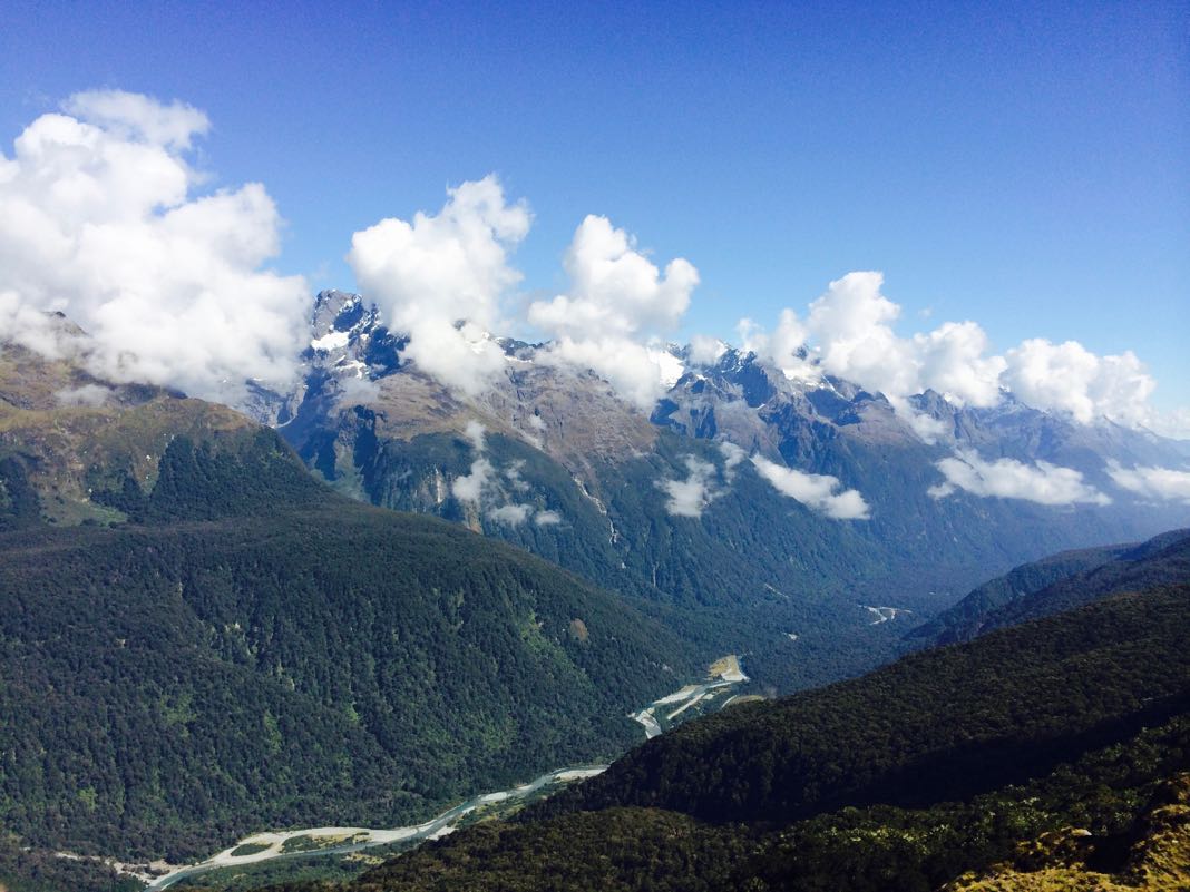
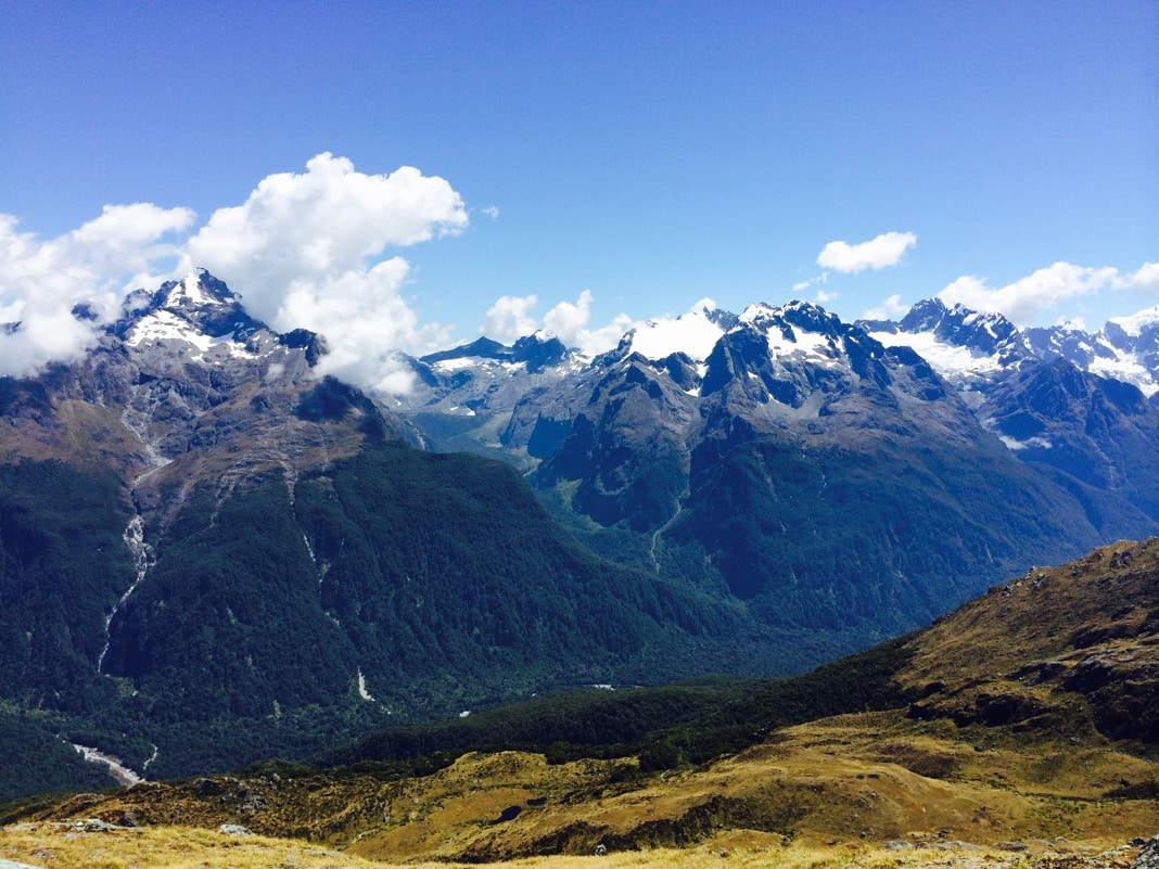
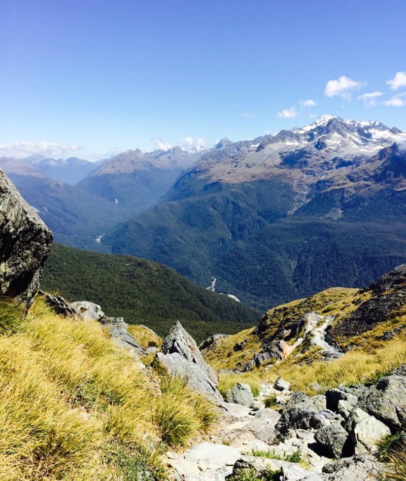
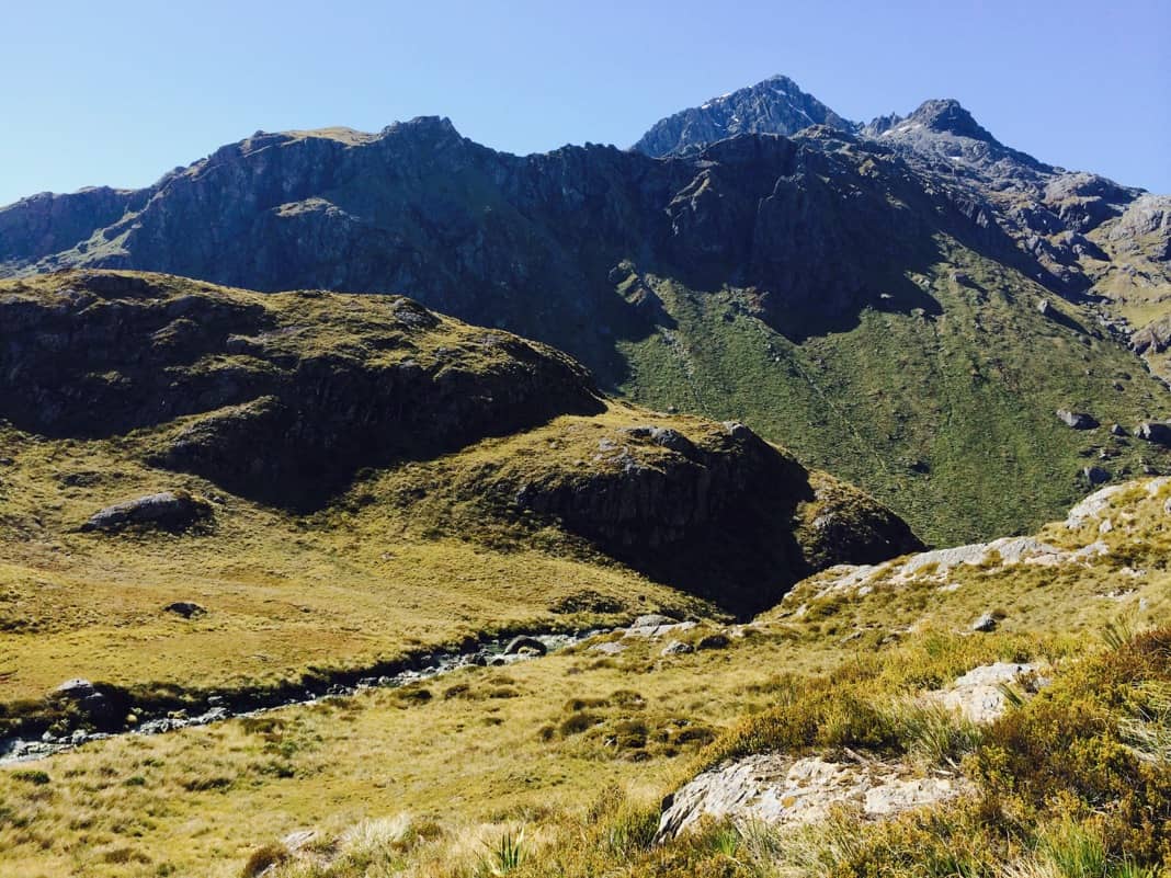
In my opinion, the Routeburn Track vastly trumps the Milford Track for spectacular views, especially in the vicinity of the Humboldt Mountains in Mount Aspiring National Park.
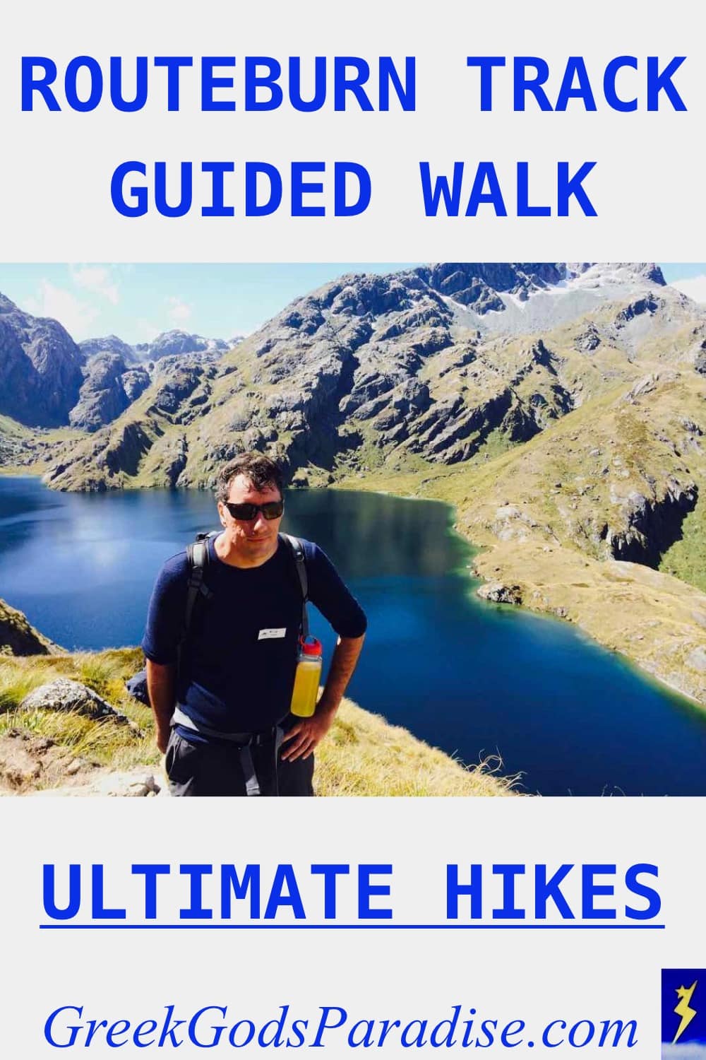
Now you know where the photo on the Greek Gods Paradise About page was taken.
The Routeburn Track scenery was amazing in this section of the trail, so I asked one of the girl guides from Ultimate Hikes I was walking with to take my photo.
Most people who have hiked the Routeburn Track rave about the awesome hiking experience. From the picture above, you can see why.
If you love alpine views, you will love the Routeburn Track.
Just pray to the sun God Apollo for some sunny weather before you go. Otherwise, you may be disappointed if it rains or you get foggy weather.
Ultimate Hikes Routeburn
My adventure on the Routeburn Track started with a bus ride from Ultimate Hikes headquarters in Queenstown.
Yep, even though we had just completed the Milford Track walk, we still had to return back to Queenstown.
That was a bit of a disappointment, but I suppose it wasn’t too bad.
Ultimate Hikes had to drop off people who had finished the Milford Track hike. Plus, they had to pick up other people doing the Routeburn Track guided walk.
When we started making our way to the Routeburn Track, we stopped for a morning tea at Te Anau.
We enjoyed something to eat and a drink at a food establishment, and the girls from Ultimate Hikes asked us a few fun questions while some of us were sitting around eating.
One question that stuck out was: If you were to be stuck on a tropical island with only one person, who would you choose that person to be?
The catch was that you couldn’t personally know the person.
One guy said a famous science-fiction book writer from memory (possibly Isaac Asimov).
Another said Dr. Jekyll, the famous killer from London.
I said Beyoncé because she could sing for me and keep me entertained. I think one of the girls said, “Good answer.”
When you’re part of an Ultimate Hikes walking group, these are the kind of awkward things that could happen to you.
Things get even more bizarre, as you’ll soon see, with flying pancakes!
Routeburn Track Guided Walk with Ultimate Hikes
When you go with Ultimate Hikes, they start the hike at The Divide in Fiordland, and it finishes at Routeburn Road (Routeburn Shelter), where the bus waits for you.
Later on, when writing this post, I was surprised to learn that it is more commonly done the other way around, with the end of the walk, The Divide.
It probably doesn’t matter which way you walk the Routeburn Track.
I suppose the only way to know for sure is to walk the Routeburn Track in both directions to see which one offers the best perspective of views when walking the trail.
The mountain views on the Routeburn Track are stunning in all directions, so I can’t see it making that much difference.
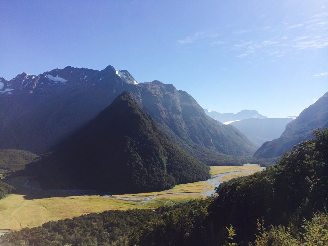
Day 1: The Divide to Lake Mackenzie
Distance: 12 km (7.5 miles), Time: 4-6 hours
The first part of the walk went smoothly with great anticipation. The feeling I had inside after getting the first glimpses of the Routeburn Track suggested that the hike would be fantastic.
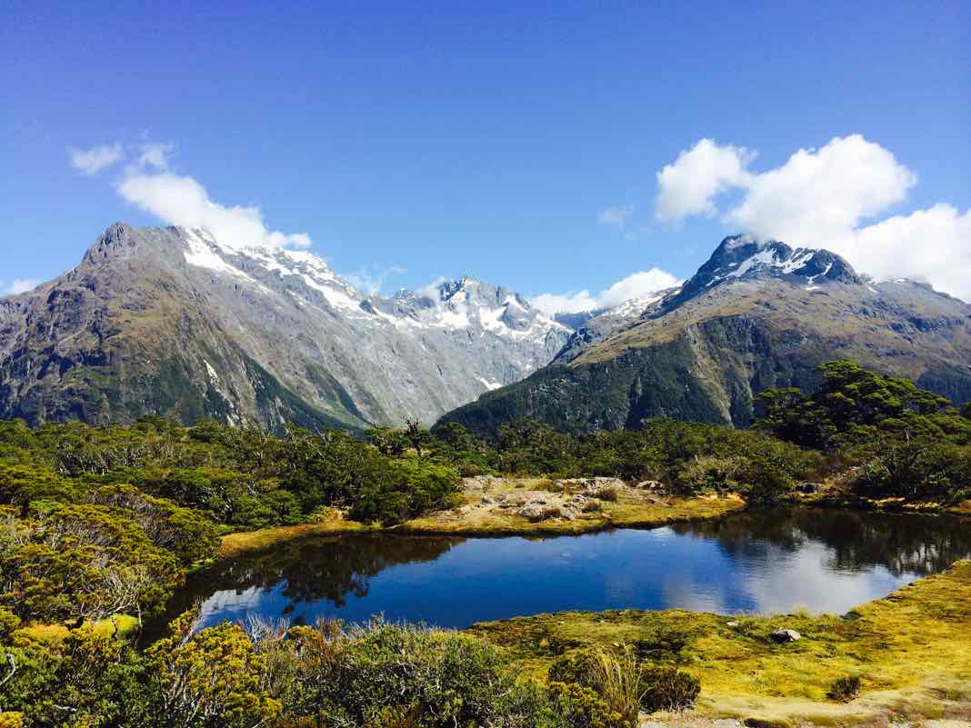
Key Summit (Optional Walk)
It didn’t take long before we arrived at an optional walk known as Key Summit.
In the picture below, you can see one of many beautiful lakes close to the Routeburn Track. You can also see the Darran Mountains in the distance.
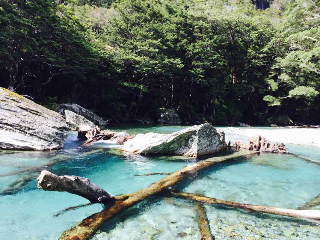
Walking past calm pools of water is so soothing, and sometimes I did cross my mind to go for a swim. However, the water is freezing.
I discovered this myself while bathing in a pool beside a waterfall on the Milford Track.
After going for a dip during my Milford Track guided walk, I felt no inclination to do the same thing on the Routeburn Track, even though the weather was way hotter.
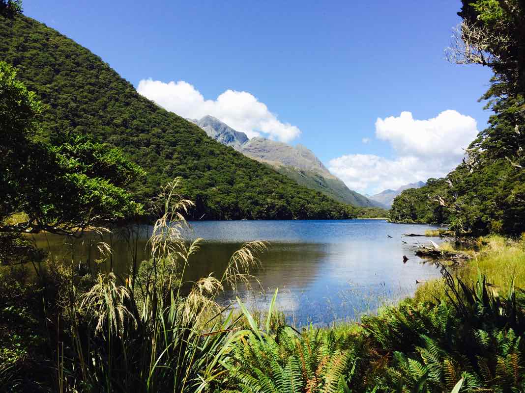
Lake Howden
After that short walk, it didn’t take long to reach Lake Howden Hut.
I can still remember Lake Howden Hut because of its beautiful location on the Routeburn Track, but unfortunately, it ended up being destroyed by a mudslide in February 2020.
We had lunch outside the hut, and it was magical! I think they have picnic tables in the area now. Here is a view of Lake Howden.
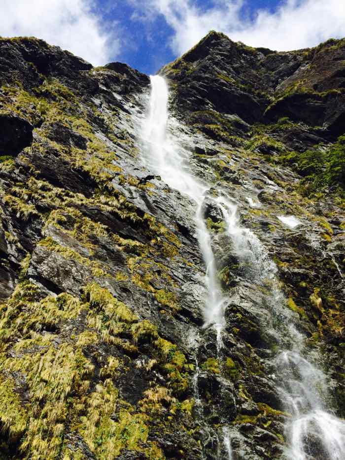
Earland Falls
The great-looking waterfall you see below is known as Earland Falls.
Seeing the 174 m (570 ft) cascade is impressive, but after seeing the awesomeness of Sutherland Falls on the Milford Track, it didn’t quite have the same wow factor.
You arrive at the waterfall after a 13.5 km walk from The Divide — the main starting point of the Routeburn Track.
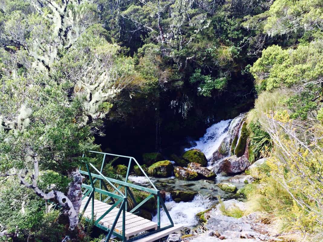
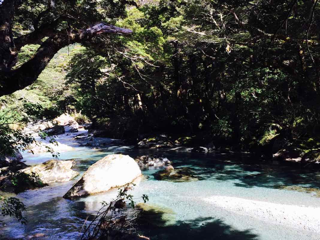
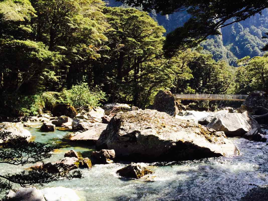
Shortly after leaving Earland Falls, hikers had to cross a river on a short footbridge.
About half an hour later, I took this photo of the Hollyford River while walking along the Routeburn Track.
At the end of the first day of our guided walk with Ultimate Hikes, we finished at Lake Mackenzie Lodge.
Day 2: Lake Mackenzie to Routeburn Falls
Distance: 11 km (6.9 miles), Time: 4-6 hours
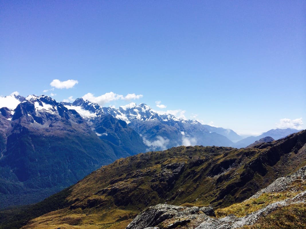
One of my biggest surprises was seeing snow on the mountains in January, something I never expected to see.
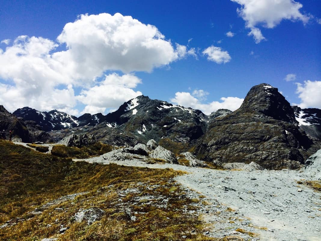
The most memorable section of the Routeburn Track walk for me was around the Harris Saddle. More specifically, hiking to the top of Conical Hill.
At Harris Saddle, there was a simple cabin/hut where we first had lunch.
Harris Saddle is near the high point of the Routeburn Track, about 1,254 m above sea level.
Conical Hill (Optional Walk)
Conical Hill is 1,515 m above sea level.
Straight after lunch, every walker (well I assume everyone) hiked up to the top of Conical Hill. It added an extra 2 km to the hike, but it was worth the extra effort.
Conical Hill is an optional walk (1-2 hr return), but whatever you’re thinking at the time, make sure you don’t miss it unless the weather is terrible.
The track leading up to Conical Hill is filled with rocks and is way more challenging than the rest of the walk along the Routeburn Track.
The hike up was hazardous and surprisingly very enjoyable.
Here is the first view that attracted my attention on Conical Hill.
Further to the right is this view.
In the other direction, you can walk further up the slope to take in more views.
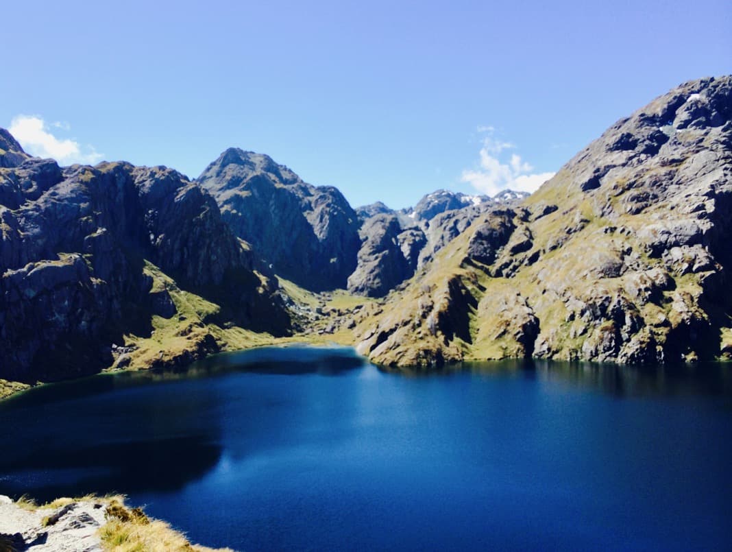
Below, is my favorite picture of Lake Harris. From this perspective, the lake looks like an arrowhead.
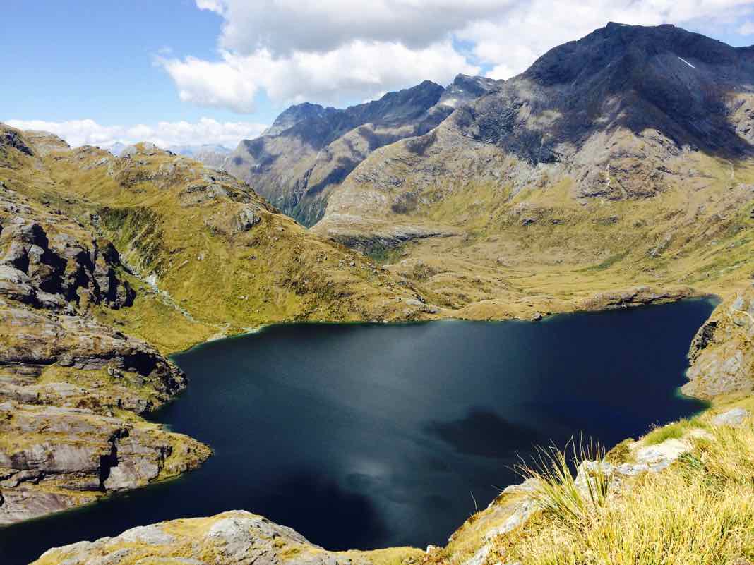
Further to the left, which you can’t see is where you can find Mt Xenicus (1912m).
I took this photo while walking down Conical Hill.
Lake Harris
After you leave Harris Saddle, the Routeburn Track winds down to Lake Harris.
Here you can see tarns and Lake Harris, the lake furthest away.
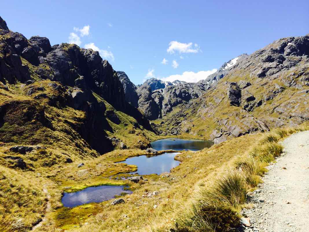
Ten minutes later, Lake Harris comes into view. The Valley of the Trolls is also visible.
Beautiful scenery is everywhere on the Routeburn Track.
Near the end of the day, we were approaching Routeburn Falls.
Below is a picture taken from above the Routeburn Falls Hut complex.
On this occasion, I have to say, I was a bit jealous of the self-guided walkers because public walkers seemed to have the best accommodation spot. It wasn’t fair!
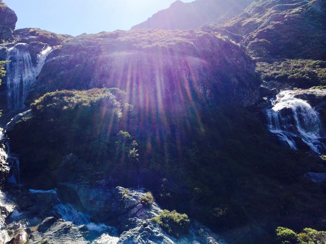
Soon after I saw Routeburn Falls, which Lake Harris feeds. The waterfall divides into two main branches over different cliff ledges.
A large beam of light appears in the middle of the pic, so no, that isn’t part of the waterfall.
All up, the second day of the Routeburn Track guided walk with Ultimate Hikes was the best! It had to be the best day out of the three-day guided walk.
Routeburn Falls Lodge
On our last night, we stayed at Routeburn Falls Lodge. I would never have dreamed of the need to catch our dessert for supper.
Unfortunately, Ultimate Hikes doesn’t like to make things too easy for you when staying at expensive lodges. They still like you to earn your tucker (Aussie slang for food).
Can you see the pancake flying under the tap in the middle of the picture?
Whoever missed catching it on their plate missed out on eating dessert, and no one wanted to miss out on eating a yummy pancake.
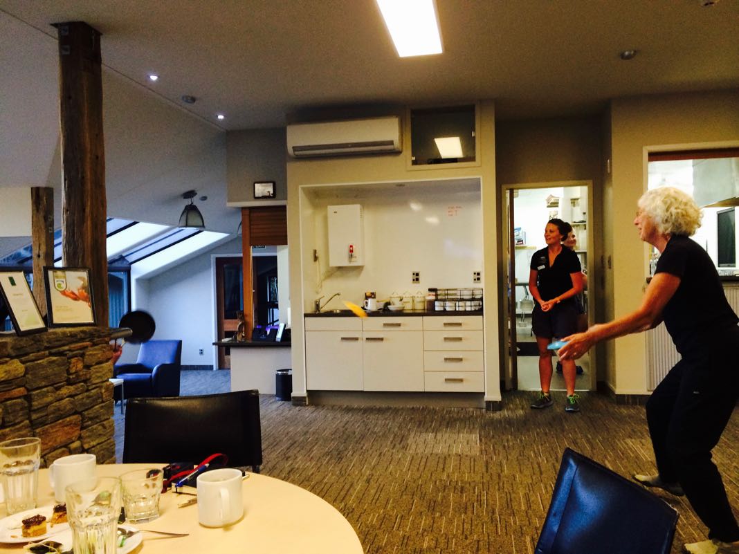
Everyone had a turn.
You can see a flying pancake headed toward this French guy, an employee of Google.
It can be seen inside the red hand-drawn crown.
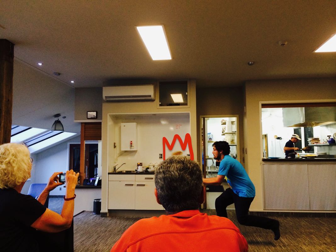
The pancake is right on top of this guy’s head.
When my turn came, I caught the pancake, but some of it dangled off the plate and almost fell off and splattered onto the ground.
Luckily, whoever dropped a pancake (and many did) ended up getting lucky. The cooking staff had a surprise backup pancake waiting for them.
The friendly cooks gave everyone a new pancake to eat, no matter what happened 🙂
I was planning to eat my partially destroyed pancake, but they still insisted on giving me another one to eat.
It made me feel guilty because it seemed like a waste, but I wasn’t going to turn down a fresh one. It was pretty delicious!
Day 3: Routeburn Falls to Routeburn Road
Distance: 9 km (5.7 miles), Time: 3-4 hours
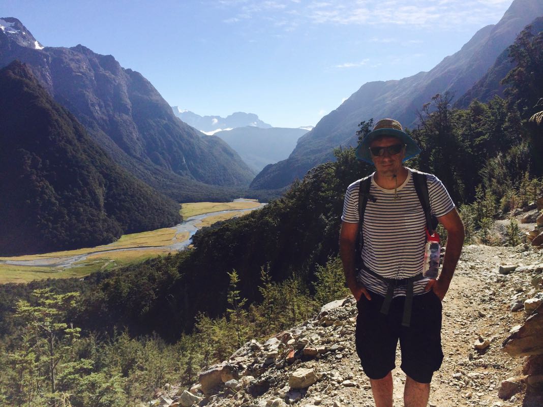
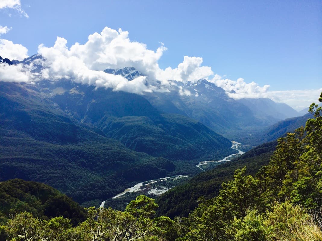
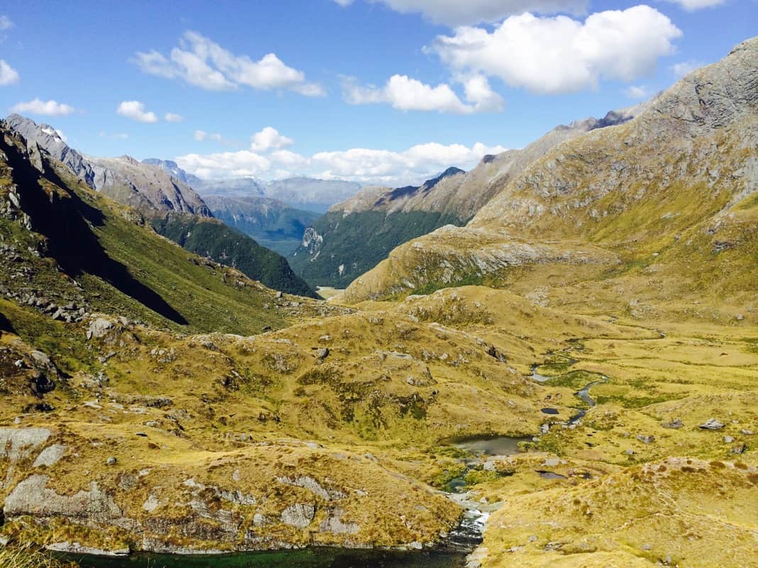
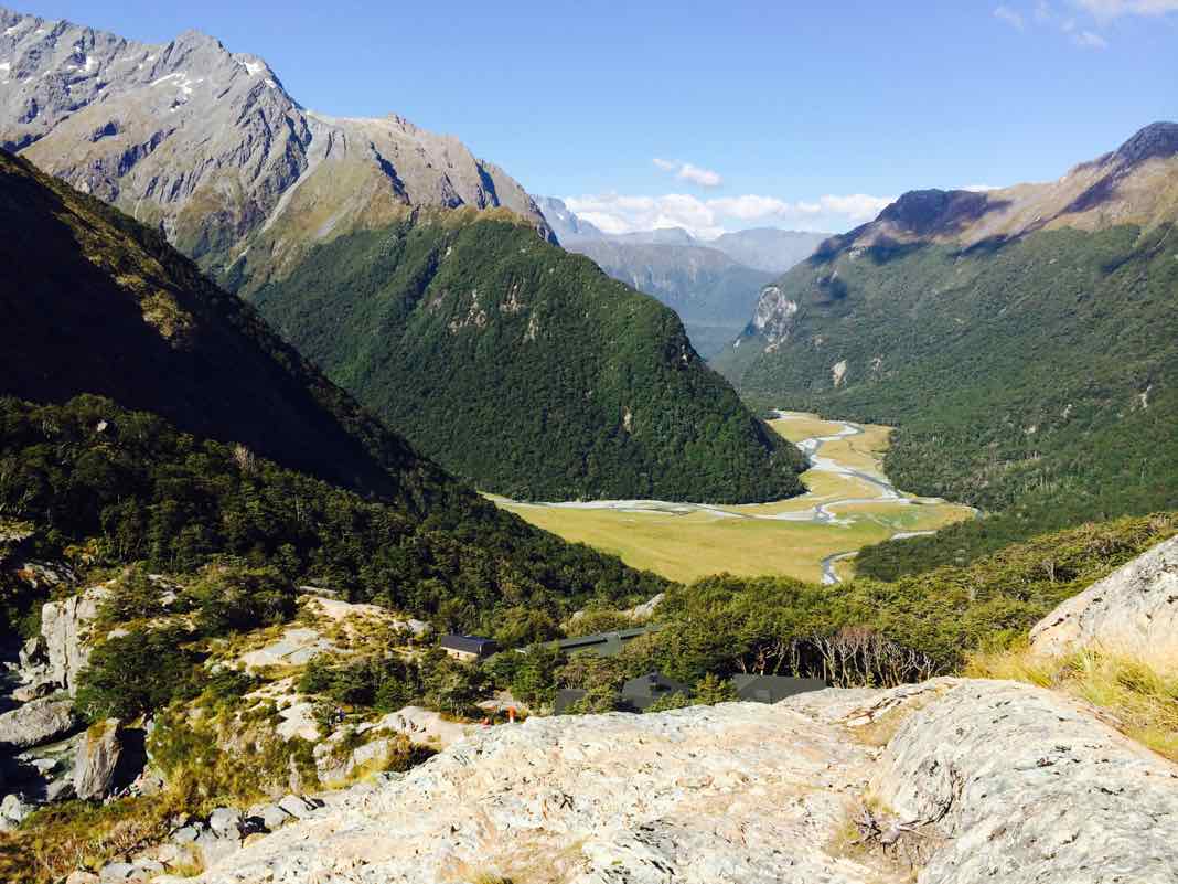
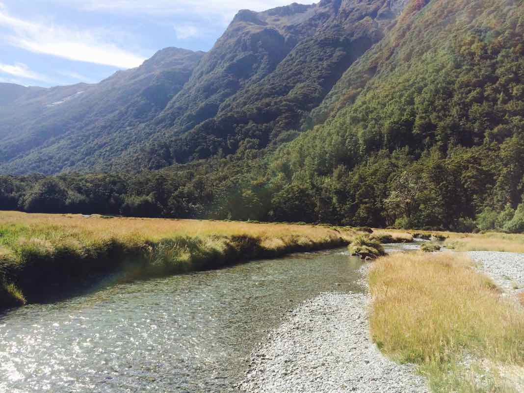
The last section of the walk had a paradise feel about it, probably because it was in the Mount Aspiring National Park area.
Best Views on the Routeburn Track
Seeing the Routeburn Flats valley and the Humboldt Mountains was a major highlight.
After a while, when tramping (Kiwi word for long-distance walking in rough country) along, you will end up on the Routeburn Flats where this serene river flows.
As soon as you saw a river crossing bridge, you couldn’t wait to walk over it.
We all spent some time relaxing at the great spot (below) since it was a meeting spot for lunch.
I think I got my feet wet here as the rocks looked tempting.
The Routeburn Track guided walk with Ultimate Hikes ended up being a fantastic experience.
If you ever want to go for a long hike in New Zealand, I highly recommend walking the Routeburn Track. You will love it.
Guided Walk or Self-Guided (Independent)
Remember, you don’t have to take an expensive guided walk with Ultimate Hikes to do this hike.
The other option is to walk the Routeburn Track independently. Just plan everything yourself.
Here’s a little secret. Going on a self-guided walk (independently) on the Routeburn Track is a smart move. I’m sure I wouldn’t have been disappointed if I had done the trek independently.
Routeburn Track Map
The following map shows you the approximate distances when walking the Routeburn Track.
If you do the Routeburn Track guided walk with Ultimate Hikes, you’ll stay at Lake Mackenzie Lodge and Routeburn Falls Lodge.
The Routeburn Track map also shows you a few places of interest, including the location of Key Summit and Conical Hill.
I can tell you that Conical Hill is a great walk. It was one of my biggest highlights, so try not to miss it. The hike on the way up is extra challenging, but it is worth it.
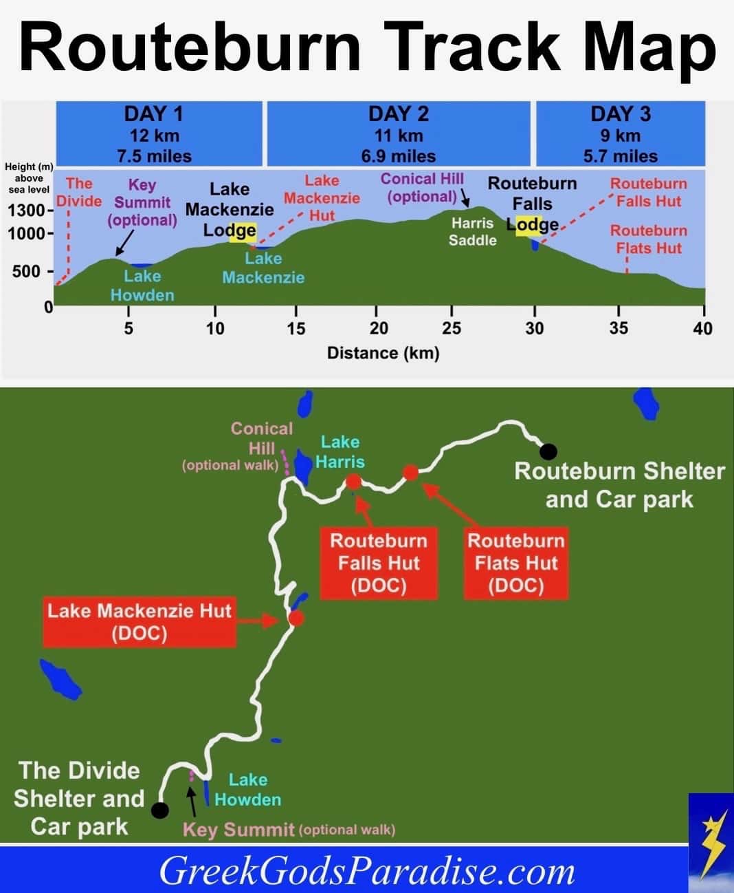
The huts shown in red boxes are the public huts. Staying at these huts is way cheaper than staying in the lodges with Ultimate Hikes.
We started at The Divide in Fiordland and completed the hike at the Routeburn Shelter in Mount Aspiring National Park.
Routeburn Track and Milford Track (Differences)
Doing the 32 km (20 miles) Routeburn Track guided walk with Ultimate Hikes takes three days.
That means you spend two nights on the trail in a couple of good lodges, compared to the 5-day/4 night walk on the Milford Track.
The Routeburn Track is more of an alpine walk. You will be stunned by the magnificent mountain scenery and wide open spaces on the Routeburn Track.
Suppose some of you prefer seeing waterfalls or green forests beside you, beautiful nature, and being much closer to rivers as you walk. In that case, I’d probably recommend doing the 54 km (33.5 miles) Milford Track guided walk.
Booking a Routeburn Track Guided Walk
Here’s a photo of the walkers in our small group.
Four hikers, including myself, were doing “The Classic” guided walk. We had just finished walking the Milford Track together in the same group.
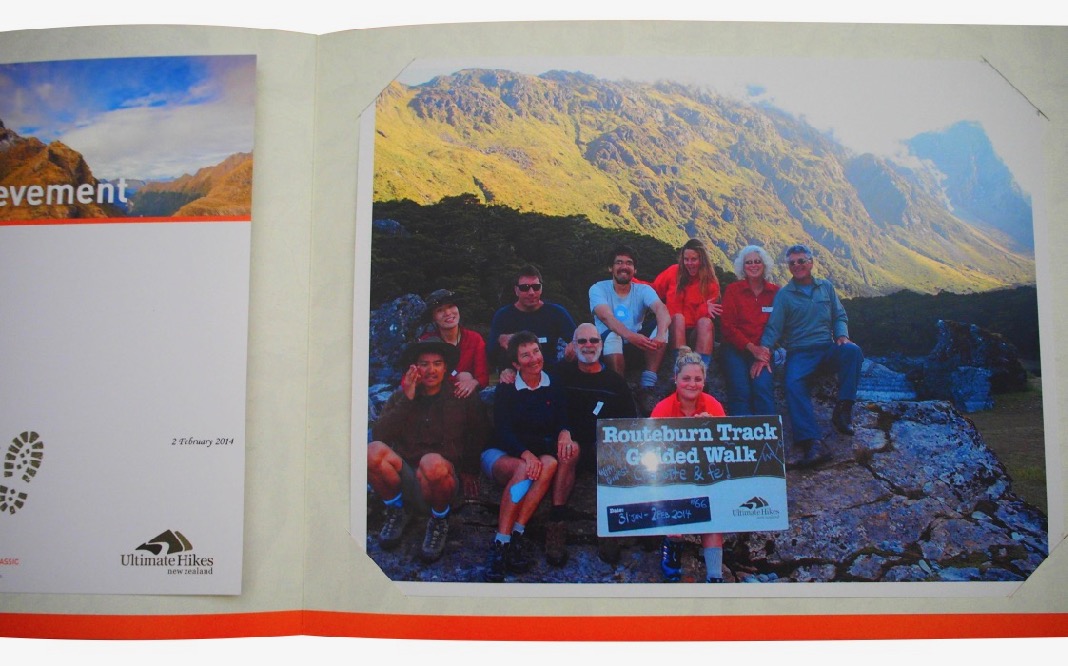
Our guides were the two girls wearing bright red/orange tops.
For further details about the Routeburn Track or to book the Routeburn Track guided walk with Ultimate Hikes, check out the Ultimate Hikes website.
Ultimate Hikes Official Website: Routeburn Track
Routeburn Track Tips and FAQ
Here are some top tips and answers to frequently asked questions about the Routeburn Track.
How long should I stay on the Routeburn Track?
Ultimate Hikes Routeburn is done over three days.
The third day seemed a bit of a waste to me. Walking the Routeburn Track over two days is the way to go. Remember, two or three days (or even four) is perfect.
Can you walk the Routeburn Track in two days?
Yes, quite easily. Walking the Routeburn Track in two days is no problem. If you start at The Divide car park, walk the 12 km to Lake Makenzie Hut. You could also hike up Conical hill as well, or if you prefer, do it first thing in the morning on the second day.
For the second and final day of your hike, walk to the Routeburn Shelter car park (about 20 km in total). Remember, you can also do the hike in reverse.
Can you walk the Routeburn Track in one day?
Yes, if you are very fit. Doing the 32 km hike in one day could be exhausting for some people, but you can do it. Fit people may even want to jog or run it.
Hiking up Conical hill is a great optional walk, adding even more distance (approx. 2 km).
Other good options: For an enjoyable one-day hike on the Routeburn Track, start from the Routeburn Shelter and walk to Harris Saddle. If you have enough time, then walk up Conical Hill. After that, return to Routeburn Shelter. You could also walk from The Divide to Earland Falls, or even further, and then back again.
Where is the best place to start on the Routeburn Track?
Ultimate hikes start at The Divide, so I assume The Divide is the best starting point. After all, Ultimate Hikes do charge a hefty fee to go on a Routeburn Track guided walk. You’d like to think that they would want hikers to have the best experience on the Routeburn Track.
The Routeburn Shelter is close to Glenorchy, a little over an hour from Queenstown. Whereas, The Divide is situated closer to Milford Sound.
If you drive from one end of the trail to the other, it takes over 4 hours, from what I have heard. So, if you start at the Routeburn Shelter and end at The Divide, you are closer to Milford Sound.
It would make visiting Milford Sound easier the next day, so that may be a good reason for starting at the Routeburn Shelter and finishing at The Divide.
Can you go on shorter hikes along the Routeburn Track?
If you wanted to, you could do a shorter walk from the Divide to Key Summit. That walk will take about 3 hours (return), and it would be effortless to arrange since no accommodation is required. You could go further along the Routeburn Track to Earland Falls and turn back when you want.
The other option is to start a hike from the Routeburn Shelter, the other side of the Routeburn Track. Seeing the Humboldt Mountains alone would be worth it.
I only recommend doing a shorter hike if your time is limited. Otherwise, the best thing to do is to walk the entire length of the Routeburn Track.
The Hollyford Track, Kepler Track, and Greenstone/Caples Track share similar scenery as the Routeburn Track.
How do I get to the start (The Divide or Routeburn Shelter) of the Routeburn Track?
Two standard options are available. Either you drive there, or you arrange a dropoff and pickup. Transportation can be arranged from either Queenstown or Te Anau.
How can I relocate my car from the start to the end of the Routeburn Track?
One of the problems if you go with your car is that at the end of the 32 km hike, your vehicle is essentially 32 km away, but in reality, it is even further away since it takes a long time to drive from one end to the other, due to longer road routes.
If you leave your vehicle in one car park, your car won’t be there once you reach the trail’s end.
The way around this is to arrange a vehicle relocation service to get your car to whatever end of the trail you desire.
Some services can do this for the Routeburn Track, but when you think about it, it is probably better, cheaper, and easier to arrange a dropoff and pickup.
If you want to take your vehicle, I have heard of one vehicle relocation service where you place a key inside a metal box. You then place the container with a combination lock underneath your car.
A driver will come along while you are walking the Routeburn Track and transport your vehicle to the other car park at the other end of the trail so that it is ready for you when you get there. It could be a good option for some walkers.
If you don’t want to spend money on a vehicle relocation service, staying on the Routeburn Track for an extra night (or two) could be worthwhile, so you can walk to the end and back again.
When is the best time to walk the Routeburn Track?
The best time to walk the Routeburn Track is from the beginning of November until the end of April.
I did the walk from the 31st of January to the 2nd of February, and the weather was great.
Where can I stay close to the Routeburn Track?
You could stay at Milford Sound Lodge, Mitre Lodge, or somewhere in Te Anau.
On the “The Divide” side of the Routeburn Track, getting to Milford Sound Lodge will take about 40 minutes. Getting from The Divide to Te Anau will take about an hour.
More Great Hiking Experiences
If you love walking, here are three great reads to get you dreaming about going on a long walk.
In addition, they offer tips and inspiration for your next hiking adventure.
- Milford Track Guided Walk: Ultimate Hiking Guide
- Interview with The Smooth Escape about Greece
- Climbing Mount Olympus
Have you ever walked the Routeburn Track? How did it go? Or maybe you would love to do this hike one day. Let me know in the comments.
Pin it … Share it